On declaring Remetea and Biatorbágy
partner localities
2001
The Council of Remetea and the Representative Body of Biatorbágy,
starting from the principle of peaceful coexistence of countries and peoples and guided by the wish to:
-
-
-
-
create opportunities for mutual acquaintance between the inhabitants of the two communities;
-
support the development of tourism;
-
promote the exchange of administrative experience;
-
ensure the exchange of cultural, artistic, health and sports programmes;
-
cultivate shared cultural traditions and a sense of common belonging;
-
facilitate the deepening of relations that may develop between the economic organizations of the two contracting parties;
-
-
-
have decided to declare:
the locality of Remetea in the Republic of Romania a partner locality of Biatorbágy; and
the locality of Biatorbágy in the Republic of Hungary a partner locality of Remetea.

About Biatorbágy
Biatorbágy lies on the western edge of Pest County at the meeting point of the Zsámbék Basin and the Buda Hills; it is bordered to the south by Etyek (Fejér County), to the north by Páty and Budakeszi, to the east by Budaörs and Törökbálint, and to the west by Herceghalom. Its area is 4,379 hectares, of which 496 ha are built-up land; its population on 1 January 2013 was 12,908. Since the 1980s — especially from the 1990s onward — the settlement has experienced dynamic population growth, due in part to its proximity to Budapest and good transport connections.
Biatorbágy is easily accessible via the M1 motorway, the national Road 1 and the railway, with a connection to the M0 ring road. These transport axes have attracted industrial and residential development and have brought the town closer to Budapest.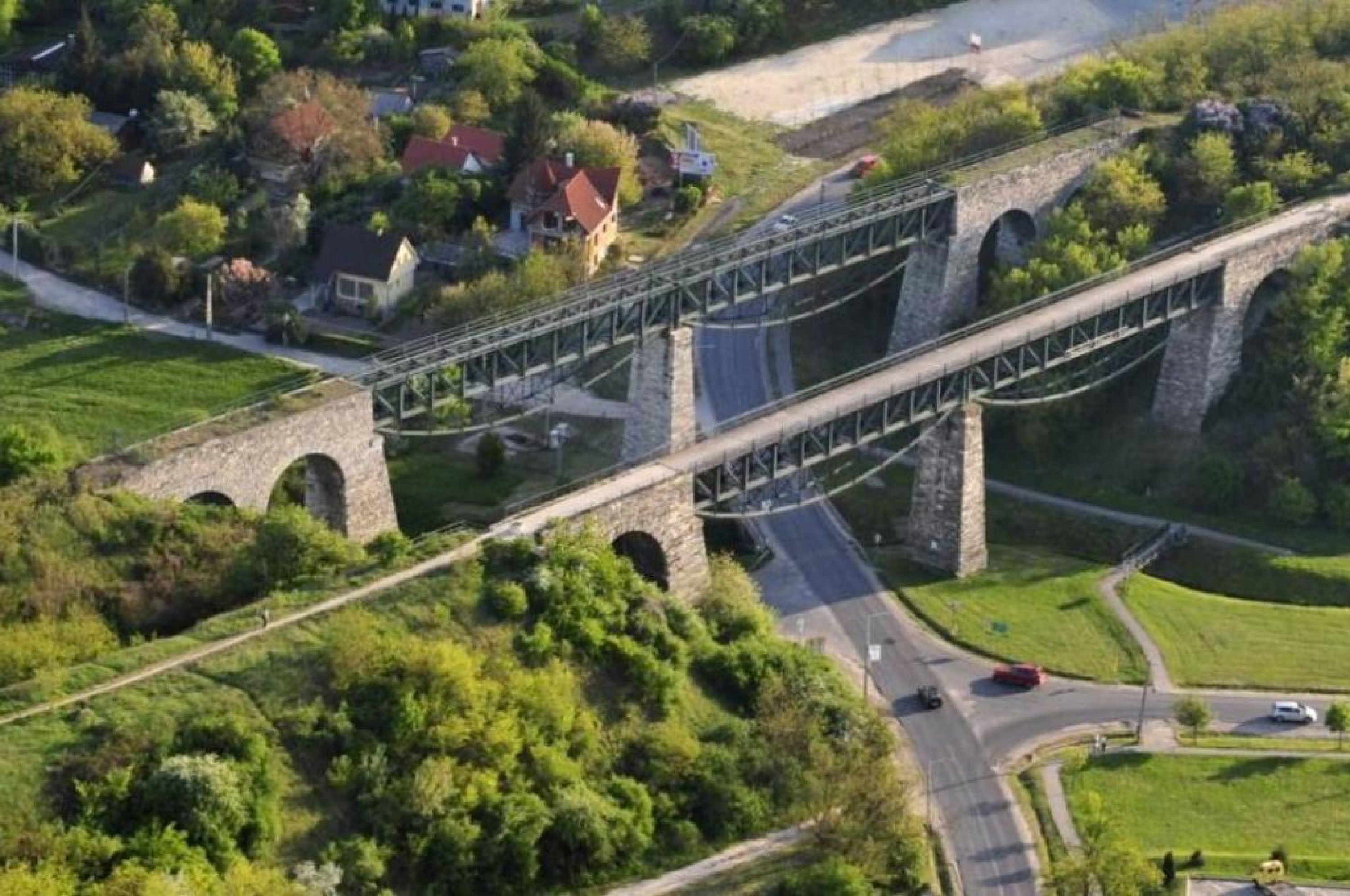
The present settlement was formed by the unification of Bia and Torbágy; the two villages were officially merged in 1966. Both have deep historical roots: the area was inhabited in prehistoric times (remains from Copper and Bronze Age have been found), and traces of Avar-period settlements have also been discovered. The railway arrived around 1883–1884; the joint station for the two villages was established in 1884, and the viaducts (the two valley bridges) were completed by 1898, these bridges have since become a symbol of the town. Regrettably, one of the 20th century’s tragic events is also connected with the viaducts: on 12 September 1931 the railway bombing carried out by Szilveszter Matuska occurred here, an episode preserved in local memory.
Traditionally the settlement had an agricultural character: in Torbágy the vineyards and orchards of Katalin Hill (Katalin-hegy) and in Bia the fishponds and orchard gardens were predominant. In the second half of the 20th century (particularly after the relocation of the railway and the construction of the motorway) more intensive recreational and residential development began: the Pecató area and its surroundings were developed, small garden plots were transformed into holiday and then residential zones, and a new settlement centre emerged on land freed up by the old railway areas. Infrastructure works carried out by the local government between 1990–1994 and urban structure plans (for example the 2002 Town Structure Plan) aimed to ensure orderly growth.
Today Biatorbágy’s character is shaped by suburbanisation and development along economic zones: the role of former large-scale agricultural land is diminishing while smaller cultivated plots and new residential areas come to the fore. Growth is nevertheless constrained by topography and natural factors, which will eventually limit further expansion. At the same time Biatorbágy has preserved its historical and landscape values — the viaducts, the fishponds and Katalin Hill remain important elements of its identity.